


Why is there a Sea in America on Old Maps?
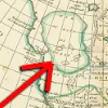
Maps from the age of discovery are filled with some pretty interesting geography. They had a mass that kept the world from tipping over, the north pole had a giant magnetic rock in the center, there was even land populated by giants. But what I’m about to show you is one of my favorite examples of weird geography on old maps. Social Media ------------------------ Map Shop - http://zacksmapshop.com/ Instagram - http://instagram.com/thegeographygeek Patreon - https://www.patreon.com/geographygeek Email Newsletter - http://eepurl.com/hSeKpj Sources ----------- https://www.biography.com/explorer/giovanni-da-verrazzano https://exploration.marinersmuseum.org/subject/giovanni-da-verrazzano/ http://blog.ncmaps.org/sea-of-verrazzano/ RareMaps.com Sources ------------ 1529 (but circa 1890) [Early Photographic Facsimile in 24-Sheet of the Verrazano World Map] - https://tinyurl.com/yhx9d9xn Sebastian Munster 1544 Map - https://tinyurl.com/48acuk27